Featuring Elfin Forest, or Is That
Mt. Israel?
January, 1998
© 1998, Tom Leech
To start the new year, we'll look at a
popular hiking and riding area smack in the middle of neighborhood communities.
And it's one that most people have a hard time finding, and even figuring out
what name it actually goes by. So here's the Forum Multiple-question Quiz. Where
is Elfin Forest? How did it get that name? What does it have to do with Mt.
Israel and how did that get its name? Where is it anyway?
ELFIN FOREST RECREATIONAL RESERVE It starts from the large paved parking lot (with facilities), with room for
horse trailers as well as vehicles. Right beside the creek is a picnic area,
with trails along Escondido Creek. There's lots of shade along here, and it's a
true babbling brook as the water courses over the rocks. Even if you don't go
any further this is a pleasant spot to explore - except when the babbling become
racing as winter rains lead to overflown banks.
One hike immediately accessible to the left is the Botanical Trail, which
makes a modest loop hike upward and back to the picnic area. To the right is the
Escondido Creek Trail, which follows the creek, then crosses over and continues
on to a maintenance road and unimproved trails.
The primary access for most people, however, is the Way Up Trail (guess why
it got its name). This is the boring, but essential, first phase of the day's
hike, 1.6 miles winding upward and about 30-40 minutes. Take water and wear lug
soles boots.
Once at the ridge, you'll see trails spreading out in all directions, through
lots of chaparral and little shade (which is why it's a good hike now, not in
August). Take the 2.7 mile Equine Incline Trail to the right, from where you'll
look across to the hillsides burned black in the last year's Harmony Grove Fire.
Head off to the left along the Valley View and Lakeview Ridge Trails, which
looks down onto Lake Hodges. (Wouldn't it be terrific if we could develop a
linking trail down to Hodges and the San Dieguito River Park?). You can choose a
loop of 4, 6 or more miles back to the starting point at the top of Way Up
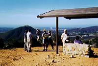
Trail. Or for an easier trek, get to Tykes' Hike Trail and the Elfin Forest
Overlook and see the world all around you from the Pacific Ocean to the
mountains. High point is about 1350 feet.
About 300 acres of the reserve were burned in the September Del Dios fire.
Already appearing are the early "fire flowers," per Ranger Sue Pelley.
She predicts a spectacular flower display in the spring, so plan a hike later as
well as now. (Similar results occurred at Iron Mountain last year.) For further
information about Elfin Forest, contact the water district at 760-753-6466. Or
TECC, The Escondido Creek Conservancy, at 760-471-9354.
Now for those quiz answers, none of which were in my usual source of San
Diego place names. Ranger Pelley provided the information, which corrected some
of my misconceptions:. Directions: From I-15. To west 78 to Nordahl Rd, becomes Citracado Parkway
south/left. Cross Mission Rd, bear right to Country Club Rd. 2-3 miles to
Harmony Grove Rd, right. 2 miles to entrance. From I-5. East on La Costa Road to
Rancho Santa Fe Rd, left; to Questhaven, right; to Elfin Forest Rd, right; to
Harmony Grove Road, right. 1.5 miles to reserve.
 Nestled among the bustling
communities of Escondido, Del Dios, San Marcos, and Carlsbad is this island of
relative tranquility. Within the 750 acre open space park are a year round
stream, picnic areas, riparian forest, great views and 17 miles of trails
available to hikers, bikers and equestrians. If you want to get either away from
or above it all, go check out the Elfin Forest, a project of the Olivenhain
Water District in cooperation with BLM (Bureau of Land Management).
Nestled among the bustling
communities of Escondido, Del Dios, San Marcos, and Carlsbad is this island of
relative tranquility. Within the 750 acre open space park are a year round
stream, picnic areas, riparian forest, great views and 17 miles of trails
available to hikers, bikers and equestrians. If you want to get either away from
or above it all, go check out the Elfin Forest, a project of the Olivenhain
Water District in cooperation with BLM (Bureau of Land Management).
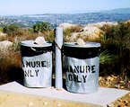 This is a hiker-friendly trail
system, with many picnic tables, rest stops, toilet facilities (with even trash
cans for recycling road apples (O.K., horse droppings) to go with these fine
views. Open 8 a.m to 4:30 p.m. (winter hours). Dogs ok, on leash. Bikes ok on
trails as marked.
This is a hiker-friendly trail
system, with many picnic tables, rest stops, toilet facilities (with even trash
cans for recycling road apples (O.K., horse droppings) to go with these fine
views. Open 8 a.m to 4:30 p.m. (winter hours). Dogs ok, on leash. Bikes ok on
trails as marked.
(1) "Elfin Forest" traces back to the religious retreat located there
since the ‘40s. Dr. Harvey Urban was affiliated with the Questhaven Fellowship
and his children started calling the area the Elfin Forest after a novel and
because it seemed to fit the miniature nature of much of the foliage here.
(2) "Mt. Israel" is another label often used to describe this area,
yet there is no Mt. Israel on the map. This name came from an early 1840's
homesteader, Robert Israel, later the lighthouse keeper at Point Loma.